Following list contains part of the supplementary functions. You may also want to check the Map Plus Home Page for more details of the basic functions that the app provides.
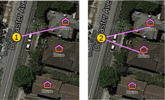
Auto Link helps user to fast create lines between special business points, for example create cables between splices, trenches between manholes, etc. What's more, it automatically builds up relationships between the linked lines and points, which means when you try to edit a point later, all its linked lines would be automatically updated to keep being linked on map. More Details.
House Count Calculation would automatically calculate and update the value of the HOUSE_COUNT property of a pole when the count of its linked house (OPTUS-CUSTOMDROP) changed. The matched sub-feature class might be applied at the same time to update its appearance on map. What's more, you can also manually trigger a re-calculation for an exiting pole's linked house count in its detail information page. More Details.
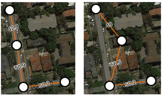
Smart Divide helps to fast break a line into two parts with a point feature inserted at the break point of specified feature class. Also, it will build up relationships automatically among these linked features.
For example, breaking a cable with a splice, or breaking a trench with a manhole, etc. More Details.
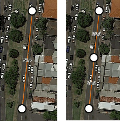
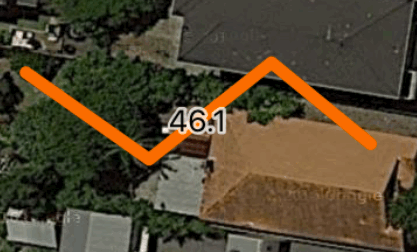
Distance Label is a newly added style to enable a line feature, such as cable, trench, etc., to calculate and display its real-time distance at the middle of the line on the map. More Details.
Property Label enables users to use the text value of a custom property to be the label displayed on map for a point feature. More Details.
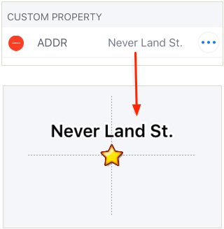
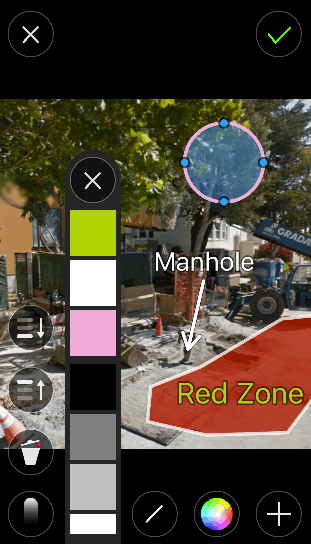
Photo Markup is a powerful add-on for adding markups to a photo. Users can add markups of lines, arrows, texts, boxes, polygons and circles to the photo with customized styles. More Details.
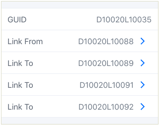
GUID is supported in this app to identify unique feature, feature class and even folder. Which could be used to build links between items, or make synchronized importing possible. More Details.
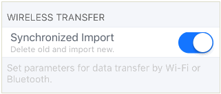
Synchronized Importing uses the GUID to identify a unique feature, class or folder, and tries to update the existing item in the app with the same item from the importing file, instead of creating a duplicated copy. Which means only one instance of the same item will be exists in User Data after importing, and users no longer need to delete the duplicated features after that.
It works for file importing of KML/KMZ/MPZ/CSV, and also works for Wireless Data Transfer through Wi-Fi or Bluetooth. More Details.
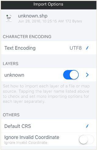
The Esri SHP, MapInfo TAB, GML and AutoCAD DXF files could be directly imported and exported. Layers could be associated with feature classes so that the features belong to it could be imported with default styles, custom properties and follow special business rules. More Details.
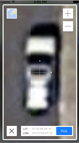
Accurate Picking enables you to pick a coordinate on a ultra-high resolution map, which could reach to zoom level of 28, and tha is 64 times of max resolution of the iOS's default map.More Details.
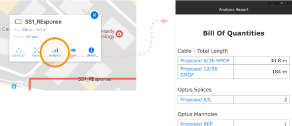
This function enables users to generate reports based on statistics of all features within a project or folder. It includes the quantity and total-length statistics for all kinds of features grouped by types, and also the SS1 Response and TASK reports.
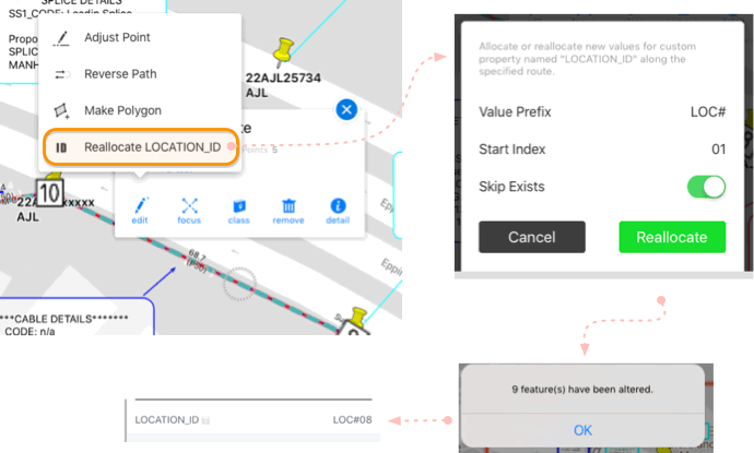
This function enables automatically allocating/re-allocating of the Location ID property for each of the task features along a giving support route.
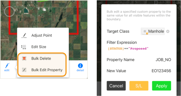
This function enables bulk deleting features or editing their specified property within a project boundary on the map.
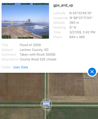
This function extract and display specified business information from a photo's EXIF metadata. Besides standard information such as coordinates, timestamp, camera name, etc., it also loads supported EXIF for XPTitle, XPSubject and XPComments, which is set and used by other business software or systems.
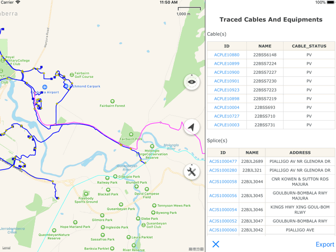
This function analyzes fibres and circuits and gives a reports for cable trace and splicing summary. The cable trace lists all cables along a selected circuit, while the splicing summary shows all splicing and spliting details for all fibres at a join equipment.